Submerged Aquatic Vegetation Mapping
Aerial Mapping of SAV Using LIDAR and Hyperspectral Imaging Flights


This research is being conducted by the US Army Corps of Engineers, Dredging Operations Environmental Research Program (DOER).  The Coastal America Foundation is proud to be associated with this effort and is providing this website access to distribute the data to researchers and managers.  Point of contact is Dr. Bruce Sabol at USACE Engineering and Research Development Center in Vicksburg, MS.
Document
Click here to download Tech Note.
The PDF to the left is the Technical Note on the SAVDOER process from USACE that explains the entire effort.  Please review and then decide on the database downloads from below that you will need.

Document
Readme File for SAVDOER
Click the map to access the ArcGIS Explorer Online Viewer
Click here to download Eelgrass and Algae Dive Video from Buzzards Bay Massachusetts. This is a large 'wmv' file so please allow time to download and buffer!
 
SAV Classification Results

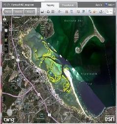
PLEASE NOTE:  ArcGIS Explorer Online requires the Silverlight 4 platform from Microsoft, and a browser which supports the Silverlight plug-in, for example current versions of Microsoft Internet Explorer or Google Chrome on Microsoft Windows, or Safari on Macintosh OS. You do not have to install any ESRI software on your computer, because the application runs within the existing web browser.

SIGN IN BELOW


Click here for external link to viewer

Click Here - For ArcGIS Desktop viewing, download the layer file
Click Here - For Google Earth viewing, download the kmz file
Click here to download SAVDOER Ground Truth data files for Plymouth, MA files
Click on the image to the left to execute a FTP download of the Plymouth Harbor, MA Access database for Ground Truth Data and associated files for SAVDOER.  The Readme file (a WORD Document) is above and in the download.  Google Earth maps (kmz files) of the site location (jpeg to the left) are also included above.

Click on the image to the right to download the FTP files for Buzzards Bay Ground Truth data and associated files for SAVDOER.  Above is the readme file.

Click Here to download SAVDOER Ground Truth data for Buzzards Bay files
Click here for short eelgrass dive video.
Mapping eelgrass provides an indication of ecological health and productivity.  This research is providing a spatially efficient coverage of this significant habitat with position accuracy.  As it is perfected and paired with other techniques, we should see better habitat management and an ability to assess long term ecosystem trends.